Wildfire Risk
Wildfire Risk is a cutting-edge database that helps assess wildfire hazards and risks. It considers various factors like terrain, climate, and human activities, such as the slope of the land, type of vegetation, frequency of past fires, proximity to water, wind patterns, non-burnable surfaces, and the distance to fire stations.
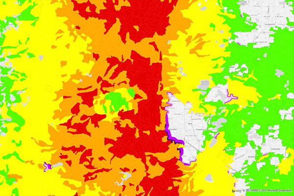
Using these factors, the model creates unique fireshed polygons across the United States, each with its own risk score. Plus, it provides detailed information at the address level, including proximity measurements to help understand the specific risk to individual structures.
Wildfire Risk Extreme
Wildfire Risk Extreme is a companion to Wildfire Risk, designed to help you understand the impact of severe wildfire conditions across the U.S. It takes into account crucial factors like temperature, humidity, and maximum wind speeds and directions during extreme fire weather. These factors are essential in predicting fast-spreading urban fires, also known as urban conflagrations.
This tool provides a detailed and comprehensive wildfire hazard and risk assessment across the country, combining predictions of wildfire severity and frequency. It delivers actionable information for any location in the U.S. under extreme weather conditions.
Visualize on a map
This dataset is also available via Data Graph API, which helps you access, enrich, and discover data like never before!
Benefits
- Assess wildfire risk exposure using a model that uniquely addresses the varying characteristics of each landscape
- Maximize your bottom line by avoiding high risk areas while identifying pockets of opportunity in generally risky areas
- Understand wildfire risk at the property level rather than a macro region and price business accordingly
- Measure a property's proximity to high and very high wildfire zones as well as the proximity to the wildland - urban interface
- Visualize wildfire risk sheds for all 50 states
Details
Wildfire Risk and Wildfire Risk Extreme provides scores for the following hazard types:
- Wildland landscape risk
- Intermix landscape risk
- Interface landscape risk
Features
- Provides a wildfire model for all 50 states that scores the risk profile of every location from 0-49
- Includes a geo-enrichment file which appends all wildfire risk information to every affected address location using a unique identifier
- Contains proximity measurements for added insight at the address level
- Includes a supporting layer of recent burn perimeters
- Delivers a supporting layer of areas impacted by the Mountain Pine Beetle
ooioioiiiooioioiioiiooioiiiooiooiiioioioiiiooioioii