Precisely Expands Wildfire Risk Capabilities for Trusted Analysis and Prevention of Extreme Urban Fires
As the risk of wildfires in developed areas continues to increase, customers can now access highly accurate data for the protection of people, properties, and land
Burlington, MA ||
Communiqués de presse
Precisely, the global leader in data integrity, today announced expanded capabilities for its Wildfire Risk product. With access to additional Wildfire Risk Extreme modeling and data, customers can accurately assess critical risk factors, including environmental conditions, for rapidly spreading urban fires across the United States. Wildfire Risk, part of the Precisely portfolio of data products, now provides a highly comprehensive and contextual view of wildfire severity and frequency in densely populated areas – enabling customers to make more confident decisions for planning and prevention.
The latest scientific research shows that the risk of extreme wildfires has doubled in the past 20 years. In the first six months of 2024 alone, nearly 20,000 wildfires burned over 2 million acres across the United States – an increasing threat that is particularly concerning in urban areas. In line with this, recent studies indicate that the property value exposed to wildfire risk during a typical mortgage period is projected to more than double by 2025, reaching over $11 billion per year and impacting approximately 3.3 million households in the United States.
Unlike traditional wildfire datasets, Wildfire Risk combines new Wildfire Risk Extreme data with representations of landscapes that reflect the true characteristics of a given location. The tool considers the impact of different variables such as the presence of vegetation or that of varying topography, including hills and valleys, which results in much more accurate and interpretable wildfire behavior analysis.
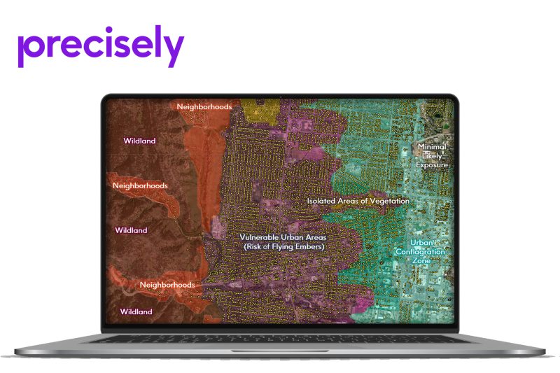
The expanded capabilities in Precisely’s Wildfire Risk product mean that customers can now access a highly comprehensive and contextual view of wildfire severity and frequency in densely populated areas. Image depicts a detailed view of the varying levels and types of wildfire and urban conflagration risks for a specific location in Boulder, Colorado (United States).
It also evaluates the effects of significant weather events, including high temperatures, low humidity, and strong winds – critical factors in devastating wildfires, such as the 2023 Lahaina fire in Hawaii. The product was developed by a team of experienced fire scientists with real-world wildfire expertise, ensuring customers can be confident that it provides the most realistic and comprehensive view of potential risks possible.
The powerful combination of Wildfire Risk and Wildfire Risk Extreme data provides insights that are essential across a wide variety of industries, including:
Insurance: insurers can more easily identify underestimated property risks for accurate policy pricing and service provision and compare the likelihood of risk under both typical and extreme conditions
Telecommunications: providers can better understand the potential impact of wildfires on cell tower placements
Public Sector: organizations and government agencies can safeguard communities and land from wildfire threats and risk of urban conflagration
Fire safety departments located in San Bernardino County, California, already rely on wildfire risk data from Precisely to strengthen local protection plans and, ultimately, help manage risk to property and citizens in an area that has seen a growing threat of wildfires in recent years.
“To help ensure a competitive advantage in successfully securing grant allocations, it’s crucial to make confident wildfire protection decisions based on trustworthy data,” said Justin Merino, Managing Director at Morongo Basin Fire Safe Council. “The bottom line is, if we fail to secure grants, that loss of funding could mean life or death for our community and property loss.”
“Urban conflagrations represent unique challenges, requiring tailored solutions that go beyond traditional risk analysis and planning,” said Dan Adams, Senior Vice President and General Manager for Data Enrichment at Precisely. “With the threat of wildfires ever-increasing, we’re humbled to be a trusted partner for customers responsible for protecting people, properties, and land across the United States.”
Precisely is renowned for its expertise in helping customers reveal maximum context from their data. Wildfire Risk is part of a comprehensive data portfolio that includes over 400 datasets containing more than 9000 attributes – designed to work together seamlessly and unlock the true potential of an organization’s data.
Learn more about the latest Wildfire Risk capabilities or find out how San Bernardino County uses wildfire risk data to establish fire resiliency and help protect its community.
About Precisely
Precisely is the global leader in data integrity, providing accuracy, consistency, and context in data for 12,000 customers in more than 100 countries, including 99 of the Fortune 100. Precisely’s data integration, data quality, data governance, location intelligence, and data enrichment products power better business decisions to create better outcomes. Learn more at www.precisely.com.
Precisely, the global leader in data integrity, today announced expanded capabilities for its Wildfire Risk product. With access to additional Wildfire Risk Extreme modeling and data, customers can accurately assess critical risk factors, including environmental conditions, for rapidly spreading urban fires across the United States. Wildfire Risk, part of the Precisely portfolio of data products, now provides a highly comprehensive and contextual view of wildfire severity and frequency in densely populated areas - enabling customers to make more confident decisions for planning and prevention.
The latest scientific research shows that the risk of extreme wildfires has doubled in the past 20 years. In the first six months of 2024 alone, nearly 20,000 wildfires burned over 2 million acres across the United States – an increasing threat that is particularly concerning in urban areas. In line with this, recent studies indicate that the property value exposed to wildfire risk during a typical mortgage period is projected to more than double by 2025, reaching over $11 billion per year and impacting approximately 3.3 million households in the United States.
Unlike traditional wildfire datasets, Wildfire Risk combines new Wildfire Risk Extreme data with representations of landscapes that reflect the true characteristics of a given location. The tool considers the impact of different variables such as the presence of vegetation or that of varying topography, including hills and valleys, which results in much more accurate and interpretable wildfire behavior analysis.
[caption id="attachment_106272" align="alignnone" width="800"] The expanded capabilities in Precisely’s Wildfire Risk product mean that customers can now access a highly comprehensive and contextual view of wildfire severity and frequency in densely populated areas. Image depicts a detailed view of the varying levels and types of wildfire and urban conflagration risks for a specific location in Boulder, Colorado (United States).[/caption]
It also evaluates the effects of significant weather events, including high temperatures, low humidity, and strong winds - critical factors in devastating wildfires, such as the 2023 Lahaina fire in Hawaii. The product was developed by a team of experienced fire scientists with real-world wildfire expertise, ensuring customers can be confident that it provides the most realistic and comprehensive view of potential risks possible.
The powerful combination of Wildfire Risk and Wildfire Risk Extreme data provides insights that are essential across a wide variety of industries, including:
Insurance: insurers can more easily identify underestimated property risks for accurate policy pricing and service provision and compare the likelihood of risk under both typical and extreme conditions
Telecommunications: providers can better understand the potential impact of wildfires on cell tower placements
Public Sector: organizations and government agencies can safeguard communities and land from wildfire threats and risk of urban conflagration
Fire safety departments located in San Bernardino County, California, already rely on wildfire risk data from Precisely to strengthen local protection plans and, ultimately, help manage risk to property and citizens in an area that has seen a growing threat of wildfires in recent years.
“To help ensure a competitive advantage in successfully securing grant allocations, it’s crucial to make confident wildfire protection decisions based on trustworthy data,” said Justin Merino, Managing Director at Morongo Basin Fire Safe Council. “The bottom line is, if we fail to secure grants, that loss of funding could mean life or death for our community and property loss.”
“Urban conflagrations represent unique challenges, requiring tailored solutions that go beyond traditional risk analysis and planning,” said Dan Adams, Senior Vice President and General Manager for Data Enrichment at Precisely. “With the threat of wildfires ever-increasing, we’re humbled to be a trusted partner for customers responsible for protecting people, properties, and land across the United States.”
Precisely is renowned for its expertise in helping customers reveal maximum context from their data. Wildfire Risk is part of a comprehensive data portfolio that includes over 400 datasets containing more than 9000 attributes – designed to work together seamlessly and unlock the true potential of an organization’s data.
Learn more about the latest Wildfire Risk capabilities or find out how San Bernardino County uses wildfire risk data to establish fire resiliency and help protect its community.
About Precisely
Precisely is the global leader in data integrity, providing accuracy, consistency, and context in data for 12,000 customers in more than 100 countries, including 99 of the Fortune 100. Precisely’s data integration, data quality, data governance, location intelligence, and data enrichment products power better business decisions to create better outcomes. Learn more at www.precisely.com.