CASE STUDY
Abeille Assurances uses geolocation data to improve the customer experience
12
projects completed with over 95 users
100
GB of spatial data points
50
GB of raster data
As an insurance industry leader in France with 4,200 employees, 1,000 general insurance agents, and 170 years of experience, Abeille Assurances provides coverage, and instills confidence to face life’s challenges and opportunities, to over three million clients.
Abeille Assurances offers a wide range of insurance products and services (including automobile, home, school, professional multi-risk), protection (GAC, loan, funeral and death, provident, and health insurance), and savings and retirement (individual or collective) for its individual, professional, agricultural, and corporate clients to insure their assets, families, and activities.
Challenges
All teams at Abeille Assurances rely on up-to-date reporting to successfully carry out their roles and ensure a high-quality client experience. To address the growing importance of the geographical nature of data in recent years, Abeille Assurances’ Data Factory created a GeoAnalytics team to improve their reporting with accurate and trustworthy data.
Societal and climate-related changes over the last several years, have made it more important than ever to use accurate data that reflects the current state of the environment. Knowing this, the GeoAnalytics team began looking for a solution. “The external environment along with climate and societal phenomena have led us to enrich our data with spatial information, which plays an important role in prevention, but also in risk reduction. Our clients needed reliable and automated geographic information, so we formed a GeoAnalytics team that is dedicated to this spatial analysis,” said Fabienne GOURINCHAS – Head of the Data Factory.
The GeoAnalytics team is responsible for enriching internal data with geographic information, creating map-based tracking, and collecting relevant external geographic data (facilitated by Open Data). The team also collaborates with the Actuarial and Climate Exposure teams to assist in risk analysis. To address the various use cases and requirements, while also disseminating information across the organization, the team needed to equip itself with the right tools.
“We’ve been using Precisely solutions to support our use cases for over 10 years. I’m extremely proud to have been involved in this project for so many years and to see positive results for Abeille Assurances’ teams,” shared Rosine GERGAUD – Geomatics Project Manager and Head of the GeoAnalytics team.
Abeille Assurances’ partnership with Precisely started with the use of MapInfo Pro, which allowed for cartographic representations and geographic analyses. Soon after, Abeille added Precisely Spectrum to geocode large volumes of data (customer addresses, contracts, claims, etc.) more efficiently and with more precision to create geolocation webservices.
While the maps created with the GIS were helpful, they were distributed to internal clients as images, which didn’t allow for modifications to be made. Therefore, users had to contact the GeoAnalytics team to modify each specific case, such as obtaining a more precise zoom or color change.
To overcome the lack of autonomy and inefficient back-and-forth process, the GeoAnalytics team sought out a tool that would allow them to create a cartographic object that is consultable, viewable, and, above all, something that each team could use based on their needs. This would enable teams to complete risk assessments much quicker; determine more relevant information; visualize different cartographies; and, to analyze the mesh more finely.

Client
Abeille Assurances
Sector
Insurances
Overview
- Headquarters, France
- An Aéma Group brand
- Over 3 million clients
- 4,200 employees
- 1,000 general insurance agents
- £7B in revenue in 2022
Outcomes
- Make risk-assessment more relevant and efficient
- Provide more autonomy to teams
- Bring more accuracy to address positioning
Solutions
- Spectrum Spatial Analyst
- Spectrum Geocoding
- Spectrum Routing
- Building Database
“We have been using Precisely solutions for more than 10 years to support our use cases. I am extremely proud to have been involved in this project for so many years and to see the results for the Abeille Assurances teams.”
Rosine GERGAUD Geomatics project manager and head of the GeoAnalytics team
Solution
To ensure that internal teams could leverage maximum geographic information while gaining more autonomy, Abeille Assurances turned to Precisely for another geospatial intelligence solution: Spectrum Spatial Analyst (SSA).
The initial purchase of the solution was made for the Climate Exposure and Underwriting teams, allowing them to dynamically visualize their policyholders and nearby risks with extreme precision and to accurately estimate exposure.
“The acquisition of the SSA tool ticked all the boxes of the various needs expressed internally to better monitor and take ownership of our exposures. The big benefit of SSA is its flexibility, which is the opposite of the ‘black box’ tools that we’re used to seeing on the market. We were able to implement it very quickly, integrate our own maps and data, and develop a custom module that was eagerly awaited by our underwriting teams,” explained Delphine JEANNEAU-BERNARD – Exposures Management Project Manager and Head of the Damage Exposures and Climate Risks department.
With its initial success, the GeoAnalytics team deployed SSA to additional users, such as the Claims teams, giving them a way to visualize Abeille Assurances’ partners (authorized garages, glass repair service providers, etc.) to better assist clients with claims. This tool enables the GeoAnalytics team to shift focus and prioritize its integration efforts to creating new projects and webservices.
“SSA is a great tool: simple, digital, innovative, with multiple query possibilities. It allows for total autonomy and quick access to the information we need with regularly updated data,” shared Gilles LEVERT – Network Animator of Agents within the External Providers Department of the Claims Solutions Directorate.
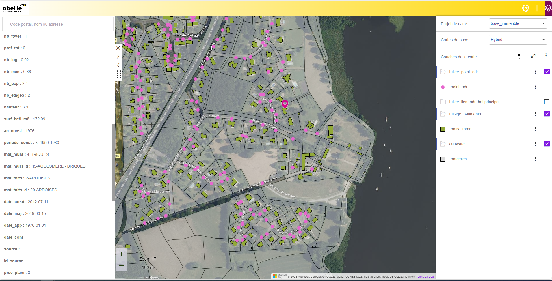
Building-precise geocoding with Spectrum Spatial Analyst
During the rollout of SSA to internal teams, it was clear that there were two different types of users. While some teams were immediately ready to use the tools, others needed more time and support to learn how to optimize it. Training sessions encouraging communication and interaction were organized, and soon it was clear that the SSA solution was very user-friendly and intuitive, leading to requests for data integration and other capabilities.
The project’s success was extremely meaningful as it helped several internal teams. As Gilles LEVERT adds, “After communicating our needs and setting up several workshops, we were able to co-create a solid foundation with relevant items for our network animation (distance between several actors, typology of providers, etc.). I am very grateful to our GeoAnalytics team for their availability, their business synthesis, their professionalism for delivering a great tool to us.”
One of the great strengths of SSA is its ability to adapt to each user’s needs. The tool provides Abeille with a view of the entire world or a specific street, or display certain data such as zoom in/out, check/uncheck the display, and thus visualize the data with precision . These capabilities provide relevant information that will support decision-making and provide reliability and accuracy.
“SSA is a great tool: simple, digital, innovative, with multiple query possibilities. It allows for total autonomy and quick access to the information we need with regularly updated data.”
Gilles LEVERT – Network Animator of Agents within the External Providers Department of the Claims Solutions Directorate
Results
With over 95 SSA Immediate Action Rapid Deployment (IARD) users and only two administrators, the GeoAnalytics team has already deployed 12 projects (with four more projects in development) with automated updates and controlled tool administration management. As a result, users can now access relevant information autonomously to support their decision-making.
Recently, Abeille Assurances also purchased the Base Immeubles database repository (FR market solution) from Precisely to achieve precise geolocation and associate detailed data on buildings, such as year of construction. These details greatly impact the assessment of insured assets and are often pieces of information that clients don’t know or don’t have immediate access to.
“The Base Immeubles database provides us with much more precise geocoding, down to the building, which helps us in all stages of the customer lifecycle; from underwriting to claims management,” adds Rosine GERGAUD.
What’s Next
Based on results thus far, Abeille Assurances is eager to continue collaborating with Precisely. The next phase involves the GeoAnalytics team transferring the tools installed on its internal servers to the cloud. This cloud migration would further simplify maintenance, offer high-availability, and therefore, improve internal processes.
“SSA allows us to develop our efficiency in terms of risk understanding; risk concentration areas; identification of accumulations by geographical area; exposure of risks to different natural perils; real-time monitoring of weather events; and much more. The growth opportunity is vast and we have plenty of ideas to optimize our exposure management,” adds Delphine JEANNEAU-BERNARD.
With the contribution of these technologies and innovations, Abeille Assurances will be able to continue improving its efficiency, insights, and provide a better experience to both future and current clients.
“SSA allows us to develop our efficiency in terms of risk understanding; risk concentration areas; identification of accumulations by geographical area; exposure of risks to different natural perils; real-time monitoring of weather events; and much more. The growth opportunity is vast and we have plenty of ideas to optimize our exposure management”
Delphine JEANNEAU-BERNARD – Exhibition Management Project Manager and Head of the Damage and Climate Risk Exhibitions division
