GeoVision
GeoVision is an enhanced version of PSMA’s Geoscape® product, Australia’s only nationwide representation of the built environment.
GeoVision simplifies and enhances the experience of using this nationally important dataset, and provides a picture of every building at an unprecedented level of accuracy and detail, including:
- Building height
- Roofing information
- Land cover and trees
- Solar panels
- Swimming pools
GeoVision is available and maintained for all urban, regional, rural, and remote areas of Australia.
Benefits
Public sector
- Planning, compliance, emergency management, and visualization
Telecommunications
- Line of sight and viewshed analysis, market location analysis, and RF modeling
Real Estate
- Valuation, marketing, farm mapping, and asset evaluation
Insurance
- Risk assessment, premium determination, and claims assessment
Utilities
- Building locations, solar installations, connection points, and planning
Service Providers
- Location of buildings, swimming pools, and solar installations
Details
Building Address
- Cadastral parcel identifier
- Property information
- Zoning
- Suburb and locality
- Postcode
- Local government area
- SA1 and mesh block
Building Attributes
- Roof area
- Roof pitch/complexity
- Maximum height of overhanging trees
- Number of roof vertices
- Ground-level building centroid
- Maximum roof height
- Swimming pool indicator
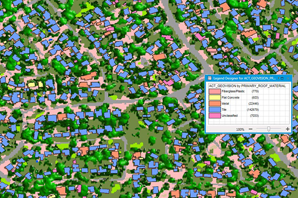
- Roof material
- Solar panel indicator
- Residential land use indicator
Landcover and tree height
- Impervious surfaces: built-up areas, roads and paths, bare earth, and buildings
- Vegetation: tree coverage, grass coverage, and unspecified vegetation
- Water
Features
- Complete national coverage including rural and remote areas
- Easy searching and reporting by
- Address
- Suburb
- Postcode
- Real property description
- Property identifier
- Simplified usage so users can be productive immediately upon installation
- Multi-resolution raster format
ooioioiiiooioioiioiiooioiiiooiooiiioioioiiiooioioii
Specifications
Coverage
Australia
Release schedule
Annually
Unit of sale
Country, State, LGA, Feature, Theme